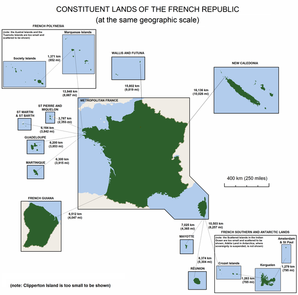
File:France-Constituent-Lands.png
Appearance

Size of this preview: 606 × 599 pixels. Other resolutions: 243 × 240 pixels | 485 × 480 pixels | 777 × 768 pixels | 1,035 × 1,024 pixels | 2,071 × 2,048 pixels | 3,337 × 3,300 pixels.
Original file (3,337 × 3,300 pixels, file size: 382 KB, MIME type: image/png)
File history
Click on a date/time to view the file as it appeared at that time.
| Date/Time | Thumbnail | Dimensions | User | Comment | |
|---|---|---|---|---|---|
| current | 15:47, 7 November 2010 |  | 3,337 × 3,300 (382 KB) | Rosss | Moved French language map to a separate file |
| 02:58, 6 September 2010 |  | 3,337 × 3,300 (299 KB) | Hypersite | Correction a few mistakes and showing of forgotten territories. -- Correction de petites erreurs et ajouts de territoires oublié. | |
| 15:52, 17 April 2008 |  | 3,337 × 3,300 (382 KB) | Godefroy~commonswiki | {{Information |Description= The constituent lands of the French Republic |Source=self-made |Date= April 17, 2008 |Author= Godefroy |Permission= |other_versions= }} |
File usage
The following 3 pages use this file:
Global file usage
The following other wikis use this file:
- Usage on an.wikipedia.org
- Usage on ast.wikipedia.org
- Usage on br.wikipedia.org
- Usage on cs.wikipedia.org
- Usage on de.wikipedia.org
- Usage on en.wikipedia.org
- Usage on es.wikipedia.org
- Usage on et.wikipedia.org
- Usage on eu.wikipedia.org
- Usage on fa.wikipedia.org
- Usage on fr.wikipedia.org
- Usage on gl.wikipedia.org
- Usage on he.wikipedia.org
- Usage on hi.wikipedia.org
- Usage on hy.wikipedia.org
- Usage on id.wikipedia.org
- Usage on ja.wikipedia.org
- Usage on ka.wikipedia.org
- Usage on km.wikipedia.org
- Usage on lfn.wikipedia.org
- Usage on lld.wikipedia.org
- Usage on lv.wikipedia.org
- Usage on ms.wikipedia.org
- Usage on nn.wikipedia.org
- Usage on no.wikipedia.org
- Usage on pdc.wikipedia.org
- Usage on pt.wikipedia.org
- Usage on ro.wikipedia.org
View more global usage of this file.


