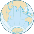
File:Indian Ocean.svg
Appearance

Size of this PNG preview of this SVG file: 440 × 440 pixels. Other resolutions: 240 × 240 pixels | 480 × 480 pixels | 768 × 768 pixels | 1,024 × 1,024 pixels | 2,048 × 2,048 pixels.
Original file (SVG file, nominally 440 × 440 pixels, file size: 408 KB)
File history
Click on a date/time to view the file as it appeared at that time.
| Date/Time | Thumbnail | Dimensions | User | Comment | |
|---|---|---|---|---|---|
| current | 19:12, 13 October 2022 |  | 440 × 440 (408 KB) | Smasongarrison | cleaner paths with svgomg // Editing SVG source code using c:User:Rillke/SVGedit.js |
| 09:41, 28 September 2020 |  | 440 × 440 (468 KB) | Sbb1413 | Uploaded a work by '''Original:''' CIA World Factbook from '''Original:''' File:Indianocean.PNG with UploadWizard |
File usage
The following page uses this file:
Global file usage
The following other wikis use this file:
- Usage on af.wikipedia.org
- Usage on an.wikipedia.org
- Usage on arc.wikipedia.org
- Usage on ar.wikipedia.org
- سلطنة عمان
- اليمن
- جيبوتي
- جزر القمر
- الهند
- الصومال
- تنزانيا
- موزمبيق
- سريلانكا
- المحيط الهندي
- ماليزيا
- باكستان
- تايلاند
- أستراليا
- القارة القطبية الجنوبية
- تيمور الشرقية
- ميانمار
- إندونيسيا
- بنغلاديش
- المالديف
- جنوب إفريقيا
- سيشل
- مدغشقر
- موريشيوس
- زنجبار
- إرتريا
- مايوت
- لا ريونيون
- جزيرة كريسماس
- جزر كوكوس
- إقليم المحيط الهندي البريطاني
- لكشديب
- أراض فرنسية جنوبية وأنتارتيكية
- جزيرة هيرد وجزر ماكدونالد
- الإقليم الأسترالي في القارة القطبية الجنوبية
- أرخبيل تشاغوس
- بوابة:المحيط الهندي
- بوابة:المحيط الهندي/واجهة
- قالب:البلدان والأقاليم المتاخمة للمحيط الهندي
- العلاقات البنغالية اللبنانية
- ليبورني
- Usage on arz.wikipedia.org
- Usage on ast.wikipedia.org
- Usage on as.wikipedia.org
View more global usage of this file.


