Climatology/Fog and Clouds

Fog
[edit | edit source]Fog is basically a cloud with its base at or very near to ground.It is formed when warm & cold currents meet.Fogs are of different kinds depending upon the nature of the cooling process.Fog is not the same thing as mist. Fog is denser than mist.It means fog is more massive and thicker than mist. Fog happens when it is very humid. In order for fog to form, dust, water vapour or some kind of air pollution needs to be in the air.
Types of Fog
[edit | edit source]There are several different types of fog, including radiation fog, advection fog, valley fog, and freezing fog, etc.
Radiation Fog
[edit | edit source]It forms in the evening when heat absorbed by the Earth’s surface during the day is radiated into the air.heat is transferred from the ground to the air, water droplets form. its also called ground fog. Ground fog does not reach as high as any of the clouds overhead. It usually forms at night. Fog that is said to “burn off” in the morning sun is radiation fog.
Advection Fog
[edit | edit source]It forms when warm, moist air passes over a cool surface is called advection.When the moist, warm air makes contact with the cooler surface air, water vapor condenses to create fog. Advection fog shows up mostly in places where warm, tropical air meets cooler ocean water. The Pacific coast of the United States, from Washington to California, is often covered in advection fog. The cold California Current, which runs along the western coast of North America, is much cooler than the warm air along the coast.
Valley Fog
[edit | edit source]It forms in mountain valleys, usually during winter. Valley fog develops when mountains prevent the dense air from escaping. The fog is trapped in the bowl of the valley. In 1930, vapor condensed around particles of air pollution in the Meuse Valley, Belgium. More than 60 people died as a result of this deadly valley fog.
Freezing Fog
[edit | edit source]It happens when the liquid fog droplets freeze to solid surfaces. Mountaint that are covered by clouds are often covered in freezing fog. As the freezing fog lifts, the ground, the trees, and even objects like spider webs, are blanketed by a layer of frost. The white landscapes of freezing fog are common in places with cold, moist climates.

Clouds
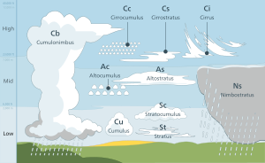
[edit | edit source]Clouds as aggregates of water droplets and ice crystals are a form of condensation and a precondition for precipitation. It represent a visible aggregate of droplets of water, or tiny ice crystals or a mixture of both. Clouds are usually product of condensation or sublimation caused by lifting process.

It play a important role in heat budget and cause cloud are devided into three layers.
- High Clouds
- Middle Clouds
- Low clouds
High Clouds
[edit | edit source]It usually found in the altitude of 6 to 12 km from the earth surface.High family clouds composed of mainly ice crystals because at greater heights amount of moisture is less and dew point is achieved at low temperatures in supersaturated situation. high clouds are generally associated with fair weather conditions.these are three types:-
Cirrus
[edit | edit source]These are detached clouds composed of white, delicate, ice filaments.It has a fibrous appearance like 'mares tails' or a silky sheen or both.
Cirrostratus
[edit | edit source]It represent a thin, milky or whitish sheet of fibrous appearance covering the sky totally or partially. It composed of tiny ice crystals.They indicate about approaching storm.
Cirrocumulus
[edit | edit source]These clouds are patches of small white flakes or small globules which are arranged in ripples or wavelike form.Wavelike regular pattern forms a mackerel sky.These clouds are least common in high clouds.
Middle Clouds
[edit | edit source]Middle clouds are in the altitude range of 2 to 6 km and have prefix alto in their names.They are composed of water droplets, ice crystals or both things. Two types are middle clouds:-
Altocumulus
[edit | edit source]It consist of layer or patches of white or grey clouds It generally arranged in fairly regular pattern of lines, groups or waves.It composed of supercooled water droplets.Altocumulus clouds differ from cirrocumulus as, cirrocumulus clouds are smaller and less dense.globular group within altocumulus clouds is known as sheep clouds or wool pack clouds.
Altostratus
[edit | edit source]Altostratus clouds appear as fibrous sheet of gray or blue-grey, covering the sky totally or partially.They are thicker than the higher cirrostratus.clouds are associated with infrequent precipitation either in the form of light snow or drizzl.
Low Clouds
[edit | edit source]Cumulus and cumulonimbus clouds have their base in the range of low clouds, but they extend upward into the middle or higher altitude.
Stratus
[edit | edit source]It generally represent grey coloured uniform layer covering much of the sky, composed of many uniform layers. These are dense and low-lying fog-like clouds.
Stratocumulus
[edit | edit source]These are large globular masses or rolls of grey or whitish or both.It arranged in lines, groups or waves.It usually associated with fair weather but occasionally rain and snow may occur.
Nimbostratus
[edit | edit source]The Latin word nimbus means ‘rain cloud’ and stratus stands for layered.These are rainy clouds. clouds bring light to moderate rainfall for long durations over widespread areas.The rain, snow and sleet are associated with these clouds but never accompanied by thunder, lightning or hail.
Cumulus
[edit | edit source]these are dense, widespread, dome-shaped (resembling a cauliflower) and have flat bases.
Cumulonimbus
[edit | edit source]clouds show great vertical extent, from a few hundred meters above the ground upward to 14 to 18 km. These clouds are common in equatorial low pressure belts and in tropical cyclones.
