Geography of France/Northeastern France
Currently, Northeastern France is made up of two regions: Grand Est and parts of Bourgogne-Franche-Comté, both created by the 2014 territorial reform of French regions. This page is divided by the historical regions of Northeastern France: Alsace, Champagne-Ardenne, Lorraine, and Franche-Comté.
Alsace
[edit | edit source]

Alsace is located in the very east of France, on the border with Germany. In fact, the easternmost commune in France, Lauterbourg, is located in Alsace. Also, Alsace's largest city, Strasbourg, borders Germany.
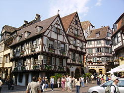
Alsace has a unique culture that blends German and French elements, as Alsace has been exchanged between the two countries many times. More traditional aspects of Alsatian culture is dominated by German culture, while more modern aspects of culture are dominated by French culture.
The people of Alsace, Alsatians, speak an Alemmanic dialect of German called Alsatian. However, after World War II, it has become more common for Alsatians to speak French.

From 1982 to 2016, Alsace was the smallest administrative region in metropolitan France, consisting of the Bas-Rhin and Haut-Rhin departments. However, territorial reform in 2014 put Alsace along with Champagne-Ardenne and Lorraine to form the new region of Grand Est.
