High School Earth Science/Introduction to Earth's Surface
Lesson Objectives
[edit | edit source]- Distinguish between location and direction.
- Describe topography.
- Identify various landforms and briefly describe how they came about.
Location
[edit | edit source]Wherever you are on Earth's surface, in order to describe your location, you need some point of reference. Right now you are probably reading this chapter at your computer. But where is your computer? It may be set up in a certain place or you may be on a laptop computer, which means you can change where you are. In order to describe your location, you could name other items around you to give a more exact position of your computer. Or you could measure the distance and direction that you are from a reference point. For example, you may be sitting in a chair that is one meter to the right of the door. This statement provides more precise information for someone to locate your position within the room.
Similarly, when studying the Earth's surface, Earth scientists must be able to pinpoint any feature that they observe and be able to tell other scientists where this feature is on the Earth’s surface. Earth scientists have a system to describe the location of any feature. To describe your location to a friend when you are trying to get together, you could do what we did with describing the location of the computer in the room. You would give her a reference point, a distance from the reference point, and a direction, such as, "I am at the corner of Maple Street and Main Street, about two blocks north of your apartment." Another way is to locate the feature on a coordinate system, using latitude and longitude. Lines of latitude and longitude form a grid that measures distance from a reference point. You will learn about this type of grid when we discuss maps later in this chapter.
Direction
[edit | edit source]If you are at a laptop, you can change your location. When an object is moving, it is not enough to describe its location; we also need to know direction. Direction is important for describing moving objects. For example, a wind blows a storm over your school. Where is that storm coming from? Where is it going? The most common way to describe direction in relation to the Earth’s surface is by using a compass. The compass is a device with a floating needle that is a small magnet (Figure 2.1).

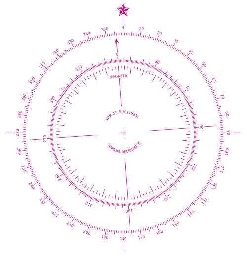
The needle aligns itself with the Earth's magnetic field, so that the compass needle points to magnetic north. Once you find north, you can then describe any other direction, such as east, south, west, etc., on a compass rose (Figure 2.2).

A compass needle aligns to the Earth's magnetic North Pole, not the Earth’s geographic North Pole or true north. The geographic North Pole is the top of the imaginary axis upon which the Earth’s rotates, much like the spindle of a spinning top. The magnetic North Pole shifts in location over time. Depending on where you live, you can correct for this difference when you use a map and a compass (Figure 2.3).

When you study maps later, you will see that certain types of maps have a double compass rose to make the corrections between magnetic north and true north. An example of this type is a nautical chart that sailors and boaters use to chart their positions at sea or offshore (Figure 2.4).

Topography
[edit | edit source]
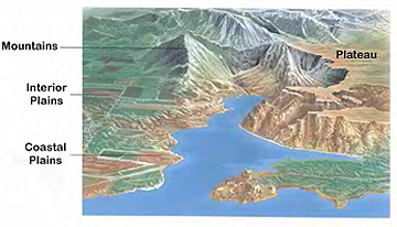
As you know, the surface of the Earth is not flat. Some places are high and some places are low. For example, mountain ranges like the Sierra Nevada in California or the Andes mountains in South America are high above the surrounding areas. We can describe the topography of a region by measuring the height or depth of that feature relative to sea level (Figure 2.5). You might measure your height relative to your best friend or classmate. When your class lines up, some kids make high "mountains" and others are more like small hills!
What scientists call relief or terrain includes all the major features or landforms of a region. A topographic map of an area shows the differences in height or elevation for mountains, craters, valleys, and rivers. For example, Figure 2.6 shows the San Francisco Peaks area in northern Arizona as well as some nearby lava flows and craters. We will talk about some different landforms in the next section.

Landforms
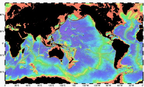
[edit | edit source]If you look at the Earth's surface and take away the water in the oceans (Figure 2.7), you will see that the surface has two distinctive features, continents and the ocean basins. The continents are large land areas extending from high elevations to sea level. The ocean basins extend from the edges of the continents down steep slopes to the ocean floor and into deep trenches.

Both the continents and the ocean floor have many features with different elevations. Some areas of the continents are high. These are the mountains we have already talked about. Even on the ocean floor there are mountains! Let's discuss each.

Continents
[edit | edit source]Continents are relatively old (billions of years) compared to the ocean basins (millions of years). Because the continents have been around for billions of years, a lot has happened to them! As continents move over the Earth's surface, mountains are formed when continents collide. Once a mountain has formed, it gradually wears down by weathering and erosion. Every continent has mountain ranges with high elevations (Figure 2.8). Some mountains formed a very long time ago and others are still forming today:
- Young mountains (<100 million years) – Mountains of the Western United States (Rocky Mountains, Sierra Nevada, Cascades), Mountains around the edge of the Pacific Ocean, Andes Mountains (South America), Alps (Europe), Himalayan Mountains (Asia)
- Old mountains (>100 million years) – Appalachian Mountains (Eastern United States), Ural Mountains (Russia).
Mountains can be formed when the Earth's crust pushes up, as two continents collide, like the Appalachian Mountains in the eastern United States and the Himalayas in Asia. Mountains can also be formed by a long chain of volcanoes at the edge of a continent, like the Andes Mountains in South America.
Over millions of years, mountains are worn down by rivers and streams to form high flat areas called plateaus or lower lying plains. Interior plains are in the middle of continents while coastal plains are on the edge of a continent, where it meets the ocean.

As rivers and streams flow across continents, they cut away at rock, forming river valleys (Figure 2.9). The bits and pieces of rock carried by rivers are deposited where rivers meet the oceans. These can form deltas, like the Mississippi River delta and barrier islands, like Padre Island in Texas. Our rivers bring sand to the shore which forms our beaches.
Ocean Basins
[edit | edit source]The ocean basins begin where the ocean meets the land. The names for the parts of the ocean nearest to the shore still have the word “continental” attached to them because the continents form the edge of the ocean. The continental margin is the part of the ocean basin that begins at the coastline and goes down to the ocean floor. It starts with the continental shelf, which is a part of the continent that is underwater today. The continental shelf usually goes out about 100 – 200 kilometers and is about 100-200 meters deep, which is a very shallow area of the ocean (Figure 2.10).

From the edge of the continental shelf, the continental slope is the hill that forms the edge of the continent. As we travel down the continental slope, before we get all the way to the ocean floor, there is often a large pile of sediments brought from rivers, which forms the continental rise. The continental rise ends at the ocean floor, which is called the abyssal plain.
The ocean floor itself is not totally flat. Small hills rise above the thick layers of mud that cover the ocean floor. In many areas, small undersea volcanoes, called seamounts (Figure 2.11) rise more than 1000 m above the seafloor. Besides seamounts, there are long, very tall (about 2 km) mountain ranges that form along the middle parts of all the oceans. They are connected in huge ridge systems called mid-ocean ridges (Figure 2.12). The mid-ocean ridges are formed from volcanic eruptions, when molten rock from inside the Earth breaks through the crust, flows out as lava and forms the mountains.


The deepest places of the ocean are the ocean trenches. There are many trenches in the world's oceans, especially around the edge of the Pacific Ocean. The Mariana Trench, which is located east of Guam in the Pacific Ocean, is the deepest place in the ocean, about 11 kilometers deep (Figure 2.13). To compare the deepest place in the ocean with the highest place on land, Mount Everest is less than 9 kilometers tall. In these trenches, the ocean floor sinks deep inside the Earth. The ocean floor gets constantly recycled. New ocean floor is made at the mid-ocean ridges and older parts are destroyed at the trenches. This recycling is why the ocean basins are so much younger than the continents.
The Earth’s surface is constantly changing over long periods of time. For example, new mountains get formed by volcanic activity or uplift of the crust. Existing mountains and continental landforms get worn away by erosion. Rivers and streams cut into the continents and create valleys, plains, and deltas. Underneath the oceans, new crust forms at the mid-ocean ridges, while old crust gets destroyed at the trenches. Wave activity erodes the tops of some seamounts and volcanic activity creates new ones. You will explore the ways that the Earth's surface changes as you proceed through this book.
Lesson Summary
[edit | edit source]- Earth scientists must be able to describe the exact positions or locations of features on the Earth's surface.
- Positions often include distances and directions. To determine direction, you can use a compass, which has a tiny magnetic needle that points toward the Earth's magnetic North Pole. Once you have found north, you can find east, west and south, using your compass for reference.
- Topography describes how the Earth’s surface varies in elevation. Mountains form the highest areas. Valleys and trenches form the lowest areas. Both continents and ocean basins have mountains and mountain ranges. They each also have plateaus, plains, and valleys or trenches.
- Mountains form as continents collide and as volcanoes erupt. Mountains are worn away by wind and water. The earth's surface is constantly changing due to these creative and destructive processes.
Review Questions
[edit | edit source]- What information might you need to describe the location of a feature on the Earth's surface?
- Why would you need to know direction if an object is moving?
- Explain how new ocean floor is created and also how ocean crust is destroyed. Why are the ocean basins younger than the continents?
- Why do nautical charts have two compass roses on them?
- What landforms are the highest on the continents?
- Explain what landforms on the continents are created by erosion from wind and water. How does erosion create a landform?
- What is topography?
Vocabulary
[edit | edit source]- abyssal plain
- The very flat, deep ocean floor.
- barrier island
- A long, narrow island parallel to the shore.
- beaches
- Areas along the shore where sand or gravel accumulates.
- compass
- Hand-held device with a magnetic needle used to find magnetic north.
- compass rose
- Figure on a map or nautical chart for displaying locations of north, south, east, and west.
- continent
- Land mass above sea level.
- continental margin
- Submerged, outer edge of the continent.
- continental rise
- Gently sloping accumulation of sediments that forms where the continental slope meets the ocean floor.
- continental shelf
- Very gently sloping portion of the continent covered by the ocean.
- continental slope
- Sloping, underwater edge of the continent.
- delta
- Often triangular shaped deposit of sediment at the mouth of a river.
- elevation
- Height of a feature measured relative to sea level.
- mid-ocean ridge
- A large, continuous mountain range found in the middle of an ocean basin; marks a divergent plate boundary.
- ocean basins
- Areas covered by ocean water.
- plains
- Low lying continental areas; can be inland or coastal.
- plateaus
- Flat lying, level elevated areas.
- relief
- Difference in height of landforms in a region.
- river valleys
- Areas formed as water erodes the landscape; often 'V' shaped.
- seamount
- Underwater, volcanic mountain more than 1,000 meters tall.
- topography
- Changes in elevation for a given region.
Points to Consider
[edit | edit source]- A volcano creates a new landform in Mexico. As the earth scientist assigned to study this feature, explain how you would describe its position in a report or scientific communication?
- Suppose you wanted to draw a map to show all the changes in elevation around the area where you live. How might you show low areas and high areas? What would you do if you wanted this map to show these changes as if you were flying above your home?
- Why do you think continents are higher areas on Earth than our ocean basins?


