Iranian History/Geography and Divisions
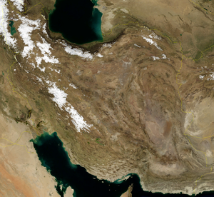
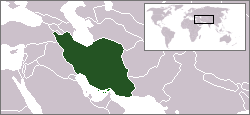
Iran forms a distinct parallelogram in the east part of the region most commonly known as the Middle East or West Asia. It is located between 32 00 N latitude and 53 00 E longitude. It has torrid plains, hot deserts and tall mountain peaks.Its history and culture is completely different from other countries of the Middle East, save Iraq which makes one wonder as to why it has been classified as a part of West Asia.
Geography
[edit | edit source]
Most of the terrain is mountainous, with the Zagros chain extending from the north-west to the south-east and the Elburz Mountains extending all along the Caspian coastline in the north. Throughout history, the two mountain ranges have often acted as a physical barrier protecting the Iranian heartland from the marauding Turkish hordes of the north and the Arabs of the south. As a result, this region has been the one least affected by foreign invasions. Though Iran had been invaded by foreigners from time to time the evil effects of conquest were often felt only in the plains of the south while the north was relatively less influenced. The Elburz mountains have, in fact, sheltered innumerable revolutionaries, freedom-fighters and banditti and was a stronghold of a declining Zoroastrian religion well into the sixteenth century.
The two mountain ranges meet at Tabriz, beside Lake Urmia in the Iranian portion of Azerbaijan. Lake Urmia,situated at the head of the Zagros Range, is associated with numerous Persian legends and was a part of the original homeland of the Avestan people.
To the south of Azerbaijan, is the country of the Kurdish tribes (Pers. Kordestan).
To the south of Kurdistan, the Zagros range curves to the right and runs parallel to the sea enclosing a narrow tract of land between the mountains and the coastline. This province known as Khuzestan with its capital at Ahvaz is the region where most of Iran's 1.5 million Arabs live.
Southern Iran, historically known as Persia, comprises roughly the areas of modern-day Khuzestan, Fars and Kirman. This is a region of great antiquity known for its culture and civilization. This was the centre of the Achaemenid and Sassanian Empires with the ruins of a magnificent Persepolis adorning its scorched terrain. Now, it seems difficult for us to imagine that this was once the centre of a mighty empire which ruled most of the known world.
To the east of Fars, lies Hormuzgan province, which comprises the island of Hormuz or Qeshm and the adjacent coastline of southern Persia. This forms the easternmost limit of Persia proper.
Political Divisions
[edit | edit source]The Islamic Republic of Iran is divided into 31 provinces.
| Province | Capital |
|---|---|
| 1. Alborz | Karaj |
| 2. Ardabil | Ardabil |
| 3. Bushehr | Bushehr |
| 4. Chahar Mahal and Bakthiari | Shahrekord |
| 5. East Azerbaijan | Tabriz |
| 6. Fars | Shiraz |
| 7. Gilan | Rasht |
| 8. Golestan | Gorgan |
| 9. Hamadan | Hamadan |
| 10. Hormuzgan | Bandar Abbas |
| 11. Ilam | Ilam |
| 12. Isfahan | Isfahan |
| 13. Kerman | Kerman |
| 14. Kermanshah | Kermanshah |
| 15. Khuzestan | Ahvaz |
| 16. Kohgiluyeh and Boyer-Ahmad | Yasuj |
| 17. Kurdistan | Sanandaj |
| 18. Lorestan | Khorram abad |
| 19. Markazi | Arak |
| 20. Mazandaran | Sari |
| 21. North Khorasan | Bojnurd |
| 22. Qazvin | Qazvin |
| 23. Qom | Qom |
| 24. Razavi Khorasan | Mashhad |
| 25. Semnan | Semnan |
| 26. Sistan and Boluchestan | Zahedan |
| 27. South Khorasan | Birjand |
| 28. Tehran | Tehran |
| 29. West Azerbaijan | Urmia |
| 30. Yazd | Yazd |
| 31. Zanjan | Zanjan |


