Planet Earth/4k. The Science of Weather Forecasting
Improving Weather Forecasting
[edit | edit source]Advances in the science of weather forecasting and the prediction of extreme weather patterns has led to numerous benefits from the agricultural industry determining when best to plant or harvest crops; to city emergency responders determining if a city needs to be evacuated before a major hurricane makes landfall. In recent years, advances in forecasting have improved from quicker observations and faster computer models, with better integration of incoming data, such as real-time temperatures and barometric readings, as well as satellite data. Since the 1940s, the number of people killed in storms has decreased, despite a rapidly growing population. Much of this drop has been due to better predications of extreme weather patterns, and better communication of impending storms. Three-day predictions of the path of cyclones have become more precise, allowing time for evacuations and other preparations that save lives and property. Improvements in forecasts are due to improved government weather data collection infrastructure provided by the United States Department of Commerce’s National Oceanic and Atmospheric Administration (NOAA), which includes the National Centers for Environmental Prediction (NCEP) and the National Weather Service (NWS). The intergovernmental European Centre for Medium-Range Weather Forecasts (ECMWF) provides weather forecasting for the European Continent. Other regions are covered by local governmental weather services which provide weather data to the public. Open access to weather and environmental data is of vital importance for communicating weather changes and help to improve human health and to make sound economic decisions.

A modern 5-day forecast is as today as accurate as a 1-day forecast was in 1980, and 9 to 10-day weather forecasts are better than they have ever been. Predictions have improved for a wide range of hazardous weather conditions, including cyclones, blizzards, floods, rain, hail, and tornadoes. Much of this has been due to increased investment in weather stations and forecasting computer models.
What makes weather forecasting better today? And can we make it even better in the future? Advances in cutting edge computer models coupled with the ability to utilizing observations from a large network of surface and satellite data quickly have led to improvements in weather forecasts. Understanding the dynamic nature of the Earth’s atmosphere has also allowed more accurate predictions to be made. However, uncertainties still exist for longer term forecasts of weather predictions. Using seasonally adjusted data and observations from previous years, coupled with incoming real time data that is synced within fast computing models of weather can be extremely powerful in predicting weather further into the future. However, even today details of weather cannot be accurately predicted beyond about 14 days. One of the major advances in extended weather forecasting beyond this limit is the discovery of the importance of global oscillations in atmosphere and ocean temperatures.
Madden-Julian Oscillation (MJO)
[edit | edit source]
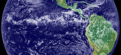
Oscillations in ocean and atmospheric temperatures result from the motion of the Earth’s water and air in response to its spin. The El Niño–Southern Oscillation (ENSO) is an important oscillation in water temperatures observed in the Pacific Ocean, and can have major implications in the convection of air. ENSO occurs mostly within the ITCZ (Intertropical Convergence Zone) near the equator.

The ITCZ is collectively a low-pressure zone that spans the equatorial regions of the Earth, however, within the ITCZ there is also variations in air pressure. With changes in ocean water temperatures below, atmospheric air can move across the ITCZ from areas of sinking air mass (relative high-pressure) to areas of rising air mass (relative low-pressure) within the overall low-pressure warm equatorial belt. This causes some areas within the ITCZ to receive more rainfall, than other areas. The ENSO is confined to the Pacific Ocean, but the more recently discovered Madden-Julian Oscillation can circulate more broadly across continents and affect the timing and strength of monsoons, influence cyclones, and result in jet stream changes that can lead to a cold polar vortex, as well as extreme heat, and flooding in North America. The improved timing of these oscillations from observations of ocean temperatures far at sea in the Pacific Ocean, is a vital tool for long term predictions of weather patterns beyond our current limits of 14 days. Such predictions could be extremely beneficial for the agricultural industry if farmers know six months or three months in advance whether it will be a wet or dry summer, as to determine the best crops to plant.
Weather Communication
[edit | edit source]
Corresponding with recent improvements in weather forecasting, the communication of weather data has greatly enlarged, enabling a larger set of users of this data. Today a quick internet search, or glance at a weather application on a Smart Phone in your pocket can reveal an incredible amount of weather information. From satellite data of cloud cover, to predications of weather in the next several days, to the chance of rain on your commute home. Details are mapped geographically, giving a wealth of information.

The communication of weather is important, because billions of people live in regions affected by extreme weather conditions. Many people live along coastlines affected by cyclones, in flood prone regions near rivers or streams, on prairies affected by tornadoes, or near mountain passes affected by winter blizzards. The value of weather information easily communicated to the public provides for better decision making at the individual level, of whether to evacuate or not when a storm approaches. Much of the communication of this data comes from various partnerships between governmental organizations like the Department of Commerce, with private local and cable news services, which utilize publicly available weather data to inform a larger audience.

| Previous | Current | Next |
|---|---|---|
