Historical Geology/Folds

In this article we shall look at folds and how to recognize them in the geological record. The reader will find it useful to have read the articles on orogeny, Steno's principles, and way-up structures before continuing.
Origin and appearance of folds
[edit | edit source]The appearance of folds shows that they are produced by the landscape being pushed sideways, as described in the article on orogeny, rather than being pushed up or pulled down from below.
This explains the normal appearance of folds (prior to erosion) as a set of parallel ridges where the landscape has been folded up (anticlines) alternating with troughs where it has been folded down (synclines). The photograph to the right shows an anticline on the left and a syncline on the right, seen from a side-on perspective.
Sufficient lateral motion will push the folds themselves over sideways, resulting in a recumbent fold, as shown in the article on orogeny.
Folds: how do we identify them?
[edit | edit source]When, as in the photograph above, a fold is intact and we can see it from the side, it is obviously a fold.

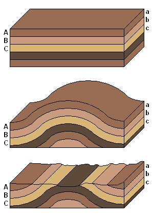
But now consider a sequence of events such as that shown in the block diagrams to the right: sediment is laid down in flat layers according to the principle of original horizontality and the principle of original continuity, then lithified, folded, and finally eroded.
As a result of the erosion, the shape of the fold will be destroyed. Even then, if we could see the rocks from the side it would not be hard to deduce that this was an eroded fold. But geologists are not usually so lucky, and instead they have to view the landscape from the top.
Nonetheless, it would not be hard to deduce what happened. Looking at the rocks, a geologist could see that the formation labeled A is the same kind of rock as a, B is the same as b, and so on. Applying the principles of original horizontality and original continuity, the only possible explanation would be that the rocks were folded and then eroded. The symmetric pattern of bands of different rock types across the landscape are by themselves an excellent indication of an eroded fold.
Even if the types of sediment didn't vary during deposition, there would be plenty of other evidence. Looking at the individual beds in the rocks, we would find them sloping up to the right on one side of the anticline, and up to the left on the other. Again, the principles of original horizontality and original continuity would tell us that at one point the layers would have been flat and met up in the middle.
Similarly we could look at the way-up structures in the rocks: on one side of the anticline they would indicate that the original up direction had been tilted to the left, and on the other side to the right.
One interesting sign of folding is that clasts and fossils within the rocks can be stretched and deformed as the rock gradually folds. Amusingly, before this process was well-understood, early paleontologists would identify the same species as two different species according to how the specimens were stretched: a fossil fish stretched one way would appear long and thin, whereas another originally identical fish stretched the other way would look short and wide.
Indications such as these allow us to identify folds even if they have been eroded, and even if we can't see them from the side.
